The Army Corps doesn't know what's in the dirt
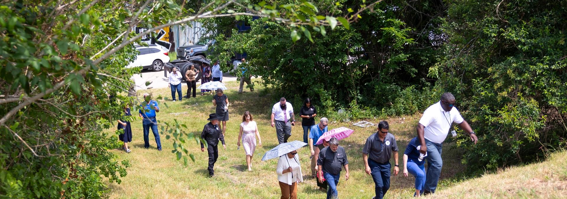
This sediment deposit site in Pleasantville has been dormant since the 1950s, when a levee wall broke and flooded nearly 40 blocks of the community. Photo: Annie Mulligan for the Environmental Defense Fund.

This post is an edited version of One Breath's free newsletter, Particulate Matters, which is sent directly to email inboxes about once a month. To sign up to receive the newsletter, please click here.
Not everyone was able to make it to the top. Standing on this ... thing, maybe 20 feet up, in Pleasantville, where sediment scraped from the Houston Ship Channel has been piled since the 1950s, I turned back toward the street, where a caravan of community members and Port Houston, Army Corps of Engineers and Environmental Protection Agency leaders had parked during a driving tour after a day of meetings in east Houston.
I saw one official struggling on the slope. They couldn't get any traction and started to backslide, kicking up dust. Two others leapt to brace their arms to ease them down and keep them from falling.
This is what happens, I was thinking. Our impersonal systems — the regulatory process, the law, the economy — allow us to build impersonal things that are all out of scale for actual people. Why is this thing in the middle of anyone's community?
Pleasantville was developed in the late 1940s for Black residents who were restricted from living elsewhere in deeply segregated Houston. By the '50s, the site where we stood — named, bucolically, Glendale — was being used to store so-called "dredge materials" excavated from the bottom and banks of a lazy, low-lying bayou to make it wider and deeper for larger and larger ships.
The current widening and deepening, Port Houston's $1 billion Project 11, could produce an estimated 1 million cubic yards of new sediment, which the Army Corps plans to put right here and at sites nearby in Channelview, Galena Park and Pasadena.
Again? More? These communities are already exposed to too much pollution from all the facilities lined up as though the Ship Channel were a freeway feeder road.
That day, the first time the port, corps and EPA had ever met with community members and environmental organizations, concerns like these were repeatedly, emphatically raised. Are the sites safe?, the corps was asked. The corps doesn’t know. Is the sediment from the Ship Channel safe? The corps can’t say.
Will you do more testing?
...
When you engineer the sites for flooding, will you stop using maps and data that Hurricane Harvey proved obsolete?
...
They're good questions. They need to be answered.
How do you expand a ship channel, anyway?
Here, Emily Hynds breaks down Project 11 into pieces: "This project — a widening and a deepening of the waterway — aims to make the channel safer for the larger ships and barges that go through daily, which often have to employ what’s known as the 'Texas Chicken' maneuver, careening toward each other before allowing the wake to set them right as they narrowly pass."
"Project 11 plans to widen the channel by 170 feet along Galveston Bay and deepen some upstream segments to 46.5 feet. But in Houston, the quality of the air and water, the stability of the climate and the health of residents have long been sacrificed for economic growth. Each expansion of the channel to accommodate larger ships and more containers — the port's goal is to handle 11 million every year by 2040, up from about 3 million now — each switcher train that hauls cargo to rail yards farther in the city, each diesel-powered truck that rumbles toward each new warehouse, comes at a cost."
'Those aren't natural hills'
One of the big unanswered questions is what's in the dirt at the sediment sites.
Lupita Rodriguez has lived in Galena Park for 30 years, writes Elena Bruess, the new environment reporter at the Houston Landing. Rodriguez lives right behind one of the sites, but she says no one has ever explained what it is. "I know something is going on there," she says.
Just what is going on, though, the Army Corps can't say. They've never tested the sites, Col. Rhett Blackmon, the corps' district commander in Galveston, confirmed at a press conference with the EPA and the port.
Why not? "They are not required to," writes Rebekah Ward in the Houston Chronicle.
So, this spring, the Healthy Port Communities Coalition (HPCC), Lone Star Legal Aid and Environmental Defense Fund (EDF) paid to test the soil.
The results are still coming in and being analyzed, but already the testing showed "arsenic and hydrocarbons at levels that should trigger a closer look" based on EPA standards, Cloelle Danforth, an EDF scientist and environmental engineer, tells Ward. And if the corps doesn't take a closer look, Danforth says, they'll be "adding to these sites without really understanding the risk."
Kick up your own dust
Following the EPA, Port Houston and Army Corps meeting, HPCC organized a town hall to allow more community members the opportunity to get questions answered.
It'll be on Monday, July 10, at the Judson Robinson Sr. Community Center in Pleasantville starting at 6:30 p.m. Childcare will be available on site, and you can request transportation at this link.
West is a writer and the communications manager with One Breath for Environmental Defense Fund. You can find them on social media @allynwest.
STAY UP TO DATE
The quality of our newsletter is considered satisfactory and poses little or no risk.
SUBSCRIBE